
SAGA’s Radar assays add detail at Trapper North, but the resource model is still open
Hole R-0094 tested the gap between 100-metre sections, where the geometry of oxide layers remains a key modelling question.
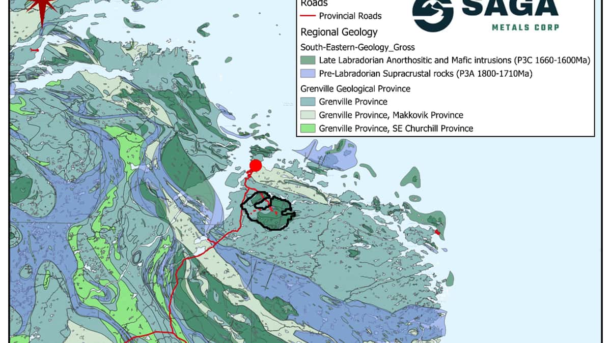
Why it matters: Assays from drilling completed after Radar’s first resource estimate could help refine the geometry and continuity of Trapper North’s oxide layers.
109.1 metres — R-0094 assay interval grading 49.88% Fe₂O₃, 8.53% TiO₂ and 0.316% V₂O₅
2,788 metres — total drilled across eight NQ holes in the post-estimate program
396.8 metres — estimated true thickness of the oxide-bearing units logged in R-0094
SAGA Metals reported a 109.1-metre assay interval grading 49.88% Fe₂O₃, 8.53% TiO₂ and 0.316% V₂O₅ in hole R-0094 at its Radar project in Labrador, Canada. The hole tested the Trapper North zone on a new section between existing drill lines. The company also reported results from R-0093, drilled on section N10.
The assays are among the first from drilling completed after the database for Radar’s initial mineral resource estimate was closed in August 2026. SAGA said the new drilling is intended to clarify the geometry of mineralization and will be considered in a later, expanded resource estimate. It has not provided a timetable for that work.
R-0094 tested the gap between established sections
R-0094 was drilled on the new N10A section, about 50 metres from the original sections, which were spaced 100 metres apart. The hole was approximately 560 metres long and aimed to test whether the oxide sequence continued between the existing sections and at depth. R-0093 crossed the centre of the zone on N10.
Both holes intersected gabbronorite containing semi-massive to massive oxides and rhythmic or intercumulus oxide units, which host titanomagnetite and ilmenite mineralization. Geological logging in R-0094 recorded 409.7 metres of oxide-bearing units from 46.7 to 521 metres downhole. SAGA estimated a true thickness of 396.8 metres for the logged sequence.
That logged interval is broader than the 109.1-metre assay interval and includes internal units without oxides. The logged length is not an assay grade or a resource estimate, and the visual description of the core does not establish the grade of the rock. The reported chemical values are based on laboratory analyses of samples; the 109.1-metre interval should not be interpreted as a true width, which was not specified.
Results remain outstanding for most of the program
The post-estimate campaign comprises 2,788 metres in eight NQ holes: R-0093, R-0094, R-0095, R-0098, R-0099, R-0102, R-0103 and R-0104. The work included drilling on intermediate sections, in the zone’s centre and on the southwest flank previously identified on sections N10 and N11. Assays beyond R-0094 remain pending.
Logged oxide-unit lengths ranged from 48.8 metres in R-0098 to 409.7 metres in R-0094. SAGA said all 102 holes logged at Radar contained oxide mineralization and that every completed hole in this program intersected oxides. Those observations describe logged geology, not the proportion of holes that will return economic grades.
Geological logging was still in progress for R-0103 and R-0104. The true thickness of the 262.3 metres of oxide units logged in R-0102 was also pending.
Oriented core will inform the next resource interpretation
SAGA said all core was oriented to measure the position of magmatic layers, lithological contacts, foliation and faults. The company plans to use those measurements alongside assays and geological logs to interpret layer continuity and the effects of folding and faulting. The new holes were outside the database used for the first resource estimate.
Core was cut lengthwise with a diamond saw, with one half retained and the other sent for analysis. Impact Global Solutions in Montreal prepared and analysed the samples. SAGA said it inserted certified standards, blanks and duplicates at regular intervals for quality control and retained coarse rejects and pulps for possible checks or reanalysis.
Radar is wholly owned by SAGA and covers about 24,175 hectares near Cartwright. The company describes a 29-square-kilometre oxide-layer zone encompassing Trapper, Hawkeye and Falcon; the detailed results in this update relate to Trapper North. The technical information was reviewed and approved by A. Miller, an independent qualified person under NI 43-101. Further assays and the interpretation of the oriented core are outstanding inputs to the later resource estimate.
More in Discoveries

Parbo intersects greenstone beneath Mount Padbury granite, forcing a gravity-model reset
GoldenEye has supplied a geological reference, while assays from pyrite-bearing Goldfinger breccias remain outstanding.
Sierra Nevada Gold hits shallow gold at As Safra, with continuity still unproven
Historic workings and high-grade rock samples mark a 400-by-100-metre corridor that had never been drilled.
Earth AI maps nearly 3 km of copper-gold at Fontenoy, but continuity remains untested
Most historical drilling reached only the first 100 metres, leaving deeper geometry central to the 2027 resource plan.